Telling the Story with Maps

I am going to break a little from the narrative account and share some more “behind-the-scenes” of my research and approach. As I mentioned at the outset, my original goal of finding out about Grandpa Dan’s Silver Star morphed into telling the story of the 71st. I really wanted to ‘walk in his shoes’ and feel connected to what he must have gone through. One of the original visions I had was re-creating the 71st’s path across France, Germany and Austria by using maps. I’m a visual / spatial kind of person so seeing a place on a map makes it more real. What I’ve discovered now is going to take it to a whole different level.

I obtained Operational Reports from the National Archives for the first few weeks of combat. I had hoped these reports would include specific locations for where the Division was. Sure enough, here’s an entry from the Cannon Company (artillery) for where they were located on the first day of actual combat:

S-3report_town_location

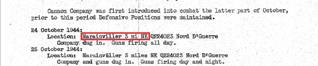
What was most intriguing is this string of gobbledygook right after the mention of the town of Marainviller:

S-3report_grid

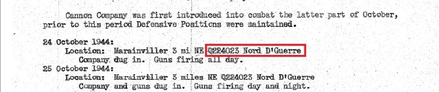
I don’t have military experience but I started to wonder if that string of letters and number was a map reference. Spending a little time with Google I started to wade into the system of continental maps that the Allies used in World War II. It was called the “Modified British System” and split the continent into large geographic areas and then further split those into a series of grid maps. More digging and I discovered a website that not only maintains the grids but can actually translate between the grid coordinates (like those in the S-3 above) to real Latitude and Longitude.

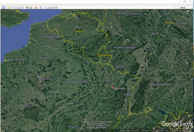
So, first step is figuring out which grid. I honestly had no idea so I pulled up Google Earth and did a search for “Marainviller”. Zooming out and turning on country borders I had this to study:

Marainviller_Google_Earth

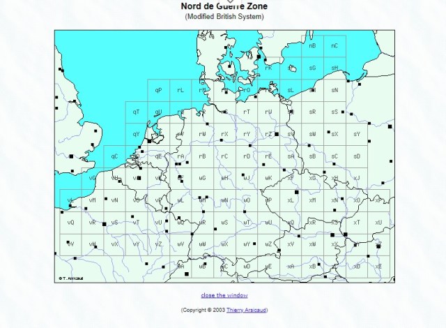
I went back to the map site and figured out that “Nord D’Guerre” in the S-3 report was telling me which big section to use. So, navigate to this page:

Nord de Guerre Zone

More studying and looking back-and-forth between the S-3, Google Earth, and this map and I had a “eureka” moment when I figured out the “Q” in the string of “Q224023” had to be the map “wQ” above.

I fumbled with the coordinate translator for a bit but finally it spit out this:

Grid_location

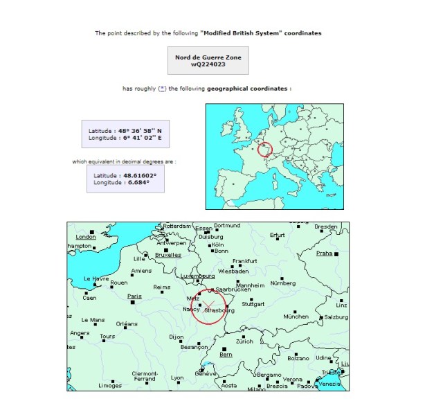
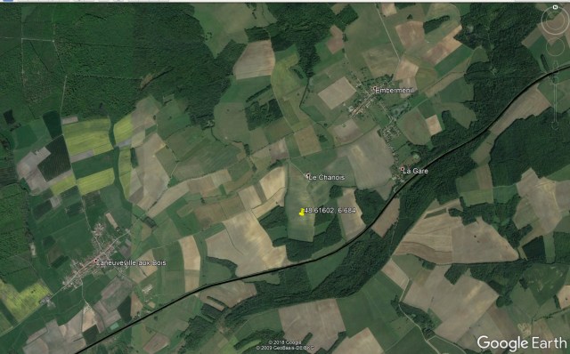
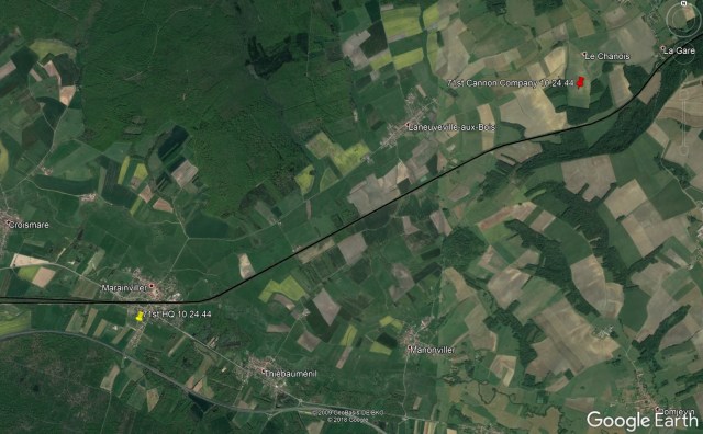
Holy crap. I’ve got the exact coordinates where the 71st Cannon Company was dug in on October 24th. What’s more fun is plugging those coordinates back into Google Earth:

Google_earth_coordinates

Just for fun, I did a quick check on where the headquarters company was. They were in the ‘present bivouac area’ near Marainviller which was just south of the town and about 4.5 miles behind the cannon company:

Oct 24th Positions

What’s even more amazing is zooming into a street view and seeing what the countryside is like. Here’s a view just outside Marainviller on the road between HQ company and the Cannon Company:

Street View-Marainviller

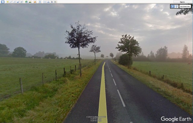
I am absolutely blown away. I never thought I would be able to get this ‘real’ when it came to walking with my granddad. I plan to generously sprinkle these types of photos into the story I’m just starting to tell.

Up next is Dan’s travels from the Cotentin Peninsula to this part of France and the 71st’s entry into combat.

Arrival in European Theatre: September – October 1944

The Monticello may have been a luxury liner in its former life, but for the next ten days it was anything but luxurious for Dan and the 71st. The men were packed like sardines in the bowels of the ship, assigned to bunks stacked three high. An infantryman from the 100th Infantry Division relates this account from traveling on the Monticello to the Pacific theater one year before:

“Once we had climbed the gangway and gotten aboard, each of us simply followed the man in front of us through a maze of hatches and companionways until we reached our assigned area. This consisted of a forest of steel pipes supporting canvas strips stretched tightly with ropes.

berthing
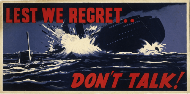
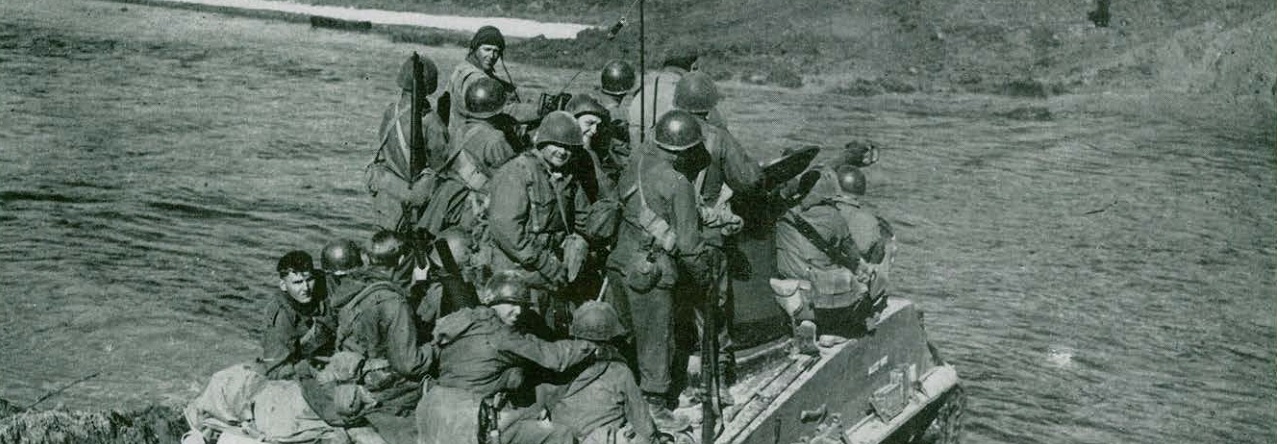
Each “hammock” was approximately two feet wide by six feet long, and was strung about two feet from the “hammock” above. These hammocks were tiered three high and the man on the uppermost one stared into a tangle of pipes immediately above his face. The men below had to contend with the indentation made by the bodies of the men above them, and each had to adjust his position to provide adequate clearance.

Aisles between the hammocks were extremely narrow and packed with duffel bags and gear, so we were constantly climbing over something. Our deck was just below the waterline, so we had no portholes and the ventilation was far less than adequate for the number of men in that confined space. ”

Queen-Mary-bunks

The men made the best of their time trying to distract one another with stories, card games, and chow time. As fall was moving over the North Atlantic, a walk in the stiff breeze above deck would have been a welcome respite from the heat, humidity and stink of man and machine below.


By the fall of 1944 Germany’s U-boat’s had largely surrendered the superiority they once claimed over North Atlantic shipping. In August of ’44 alone, 29 U-boats had been sunk  (many by aircraft at sea and at harbor) in contrast to 12 British, Allied and neutral ships sunk in UK waters. Even with the loss of tactical superiority, the U-boat threat would have been a real concern for Dan and his men. As they neared the European Continent they would have certainly been uneasy at the thought of running this once-formidable gauntlet.

tumblr_ooc24eCRwV1udy4kko1_1280.png

After 10 days at sea, on September 15th, the Monticello and the General W. H. Gordon arrived at the thoroughly wrecked port of Cherbourg, France. Dan’s unit represented the first allied reinforcements to land directly on the Euorpean mainland from the US. The appearance of the port where he debarked would have quickly introduced Dan to the destruction that had taken place in the months before he arrived.

Soon after D-Day, securing a major deep-water port on the Normandy coast became an immediate goal for the Allies. Until a port was secured, men, equipment, and supplies would have to be shipped to the UK, waterproofed, transferred to amphibious craft, and then ferried to the French coast. This potential bottleneck had to be removed and, after establishing a continuous front along the landing zones, the Allies began moving west to cut off the Cotentin Peninsula and isolate the cities of Volognes and the port of Cherbourg.

Cotentin_Peninsula


In the image above, Utah beach is identified, along with the city of Carentan to the south-west. Allied airborne troops furiously fought house-to-house to liberate the town of Carentan and secure the southern front for the allied beachhead in conjunction with the D-day landings. From June 18 – 26th, the Allies pushed west and north, gradually tightening the noose on the German garrison in and around Cherbourg, and on the 26th, General Karl-Wilhelm von Schlieben surrendered his troops. During this same time, Rear Admiral Walter Hennecke had the Kriegsmarine busy destroying everything in the port. So thorough was the destruction that Hitler awarded Hennecke with the Knight’s Cross for “a feat unprecedented in the annals of coastal defense.”  One American engineer described the German efforts as ‘a masterful job, beyond a doubt the most complete, intensive, and best planned demolition in history’. The outer breakwater had been cratered, the quay walls damaged, essential cranes destroyed, the harbor blocked with sunken ships and hundreds of mines scattered across the harbor.

It took a solid month before any deep-draft ships could enter the outer harbor waters and the 44th Infantry was the first allied troop reinforcement to land at the port. After debarking, the Division traveled inland to the vicinity of Montebourg where they set up a camp among the orchards and farms.

Over the next three weeks, Dan and the 71st Regiment received trucks, equipment, ammunition, and supplies. Most importantly, they engaged in intensive conditioning and training in hedgerow and broken-terrain fighting. This training would serve them well as they prepared to leave via train for the front itself.